

By the mid-1990s, RICK’s projects were growing in complexity and often involved multiple cities and agencies, creating a need for faster and more reliable ways to design. Engineering at the time was shifting from hand drafting to computer-aided design (CAD), and RICK recognized the value of that transition early. The company adapted the new software to fit its needs and developed a reliable system that kept projects consistent across offices as RICK moved into a new period of growth.
 At first, the technology was slow to deliver. Each office had its own setup, and even small projects took trial and error to complete with the new software. In Tucson, a group of RICK engineers began testing how CAD could be standardized and shared more efficiently across offices. They worked closely with the IT team to refine settings, fine-tuning thousands of variables until the program started running the way RICK needed it to.
“Once we realized what CAD could really do, there was no going back. You could see the future of design opening right in front of you.” —Brian Laird, Associate Principal, RICK Tucson
When Laird joined RICK in 1995, the firm had already started using early CAD programs, though each office still relied on its own methods and shortcuts. The team in Tucson formed the basis for what would later become a unified system, allowing offices to share and support work from one location to another. That groundwork continued to evolve until 2004, when RICK established a companywide CAD standard that brought higher efficiency and consistency across all offices. What began as a few experiments and “what-ifs” grew into a system that strengthened collaboration and made project delivery faster and more reliable.
 When GIS was introduced to the firm in 1996, this added another digital tool that helped teams understand their sites and support the work already underway in CAD. Instead of relying only on drawings or site visits, teams could pull up information about the terrain and the surrounding site conditions to guide their early planning decisions. It became part of the larger effort to bring information into one place and to keep the growing offices working from the same system.
“GIS added context to the work we were already doing, linking design with the data behind each project and making that information accessible to everyone involved.” —Bob Kutscher, The Daily Transcript, 2005
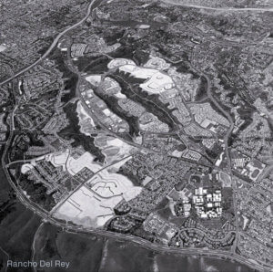
The reliability of digital tools started to show up on big projects like Rancho del Rey in Chula Vista, a master plan that stretched across hundreds of acres. Karen Van Ert joined RICK as a designer in 1992 and worked on the project a few years later, right as the team was moving from hand drafting to CAD. She remembers spending much of that time learning the software and adjusting the team’s workflows as CAD became part of the project.
“Rancho Del Rey was the moment everything changed. We were still learning the software, so there were plenty of late nights, but you could see how much faster and cleaner the work became once it was digital. I still remember how good it felt to watch everything line up the way it should.” —Karen Van Ert, Associate Principal, RICK San Diego
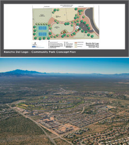
 A similar transition was happening in Arizona on the Rancho Del Lago community outside Tucson. The 1,600-acre site needed everything from site grading to roadway planning, along with design work around the Pantano Wash. Using CAD and GIS together allowed RICK teams to work from the same base information, which helped keep the design consistent across miles of infrastructure. It became one of the first projects where the digital tools guided nearly every stage of the work.
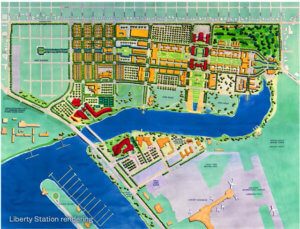
Around the same time, RICK was contributing to the redevelopment of Liberty Station in San Diego, one of the firm’s largest multidisciplinary efforts. Digital design tools made it possible for teams across planning, engineering, surveying, and landscape architecture to coordinate designs on a complex and historically sensitive site. Their work helped transform the property into a walkable community that preserved its historic character and set a model for future redevelopment projects.

While RICK was upgrading its design systems, the firm was also extending its reach. In 2001, the Irvine office opened to serve clients across Orange and Los Angeles counties. Three years later, Sacramento followed, creating a Northern California base that connected the expanding regional work. Each new office strengthened RICK’s network, making the need for shared digital systems even more essential.
As new offices opened, collaboration across the company continued to evolve. With shared CAD and GIS standards, teams could send files between offices and build on each other’s work in real time. A project design started in Tucson could be updated in San Diego and wrapped up in Irvine, all without losing detail or momentum. That kind of coordination strengthened how RICK’s teams worked together, keeping offices connected through the shared digital systems they’d adapted to their needs.
By 2005, technology was part of daily life at RICK. The early CAD and GIS systems connected offices across cities and states, transforming how teams approached their work and collaborated across every stage of a project. It was progress through technology, grounded in persistence and a drive to keep improving as RICK expanded its presence across the southwest.
As part of our 70th anniversary series, we’ll continue sharing the history and growth that have shaped RICK over the decades. Watch our news feed for future articles as the story of RICK’s history unfolds.