

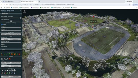
All design projects need topography. A topographic survey shows contours, or the different elevations of the land, along with existing features like trees, utilities, and roads that influence the design.
With Reality Capture, the survey team collects a much more complete record of the site, including millions of measured data points and high-resolution 360-degree imagery that can be explored long after the field work is finished.
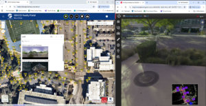
360° Topography adds an immersive experience. In addition to the CAD file, any member of the project team can access a web portal and virtually walk the site with 360° photography; it is comparable to Google Street View, but specifically for a project that you can measure from. Project teams can take additional measurements directly from the portal, even if they weren’t included in the original CAD file, with all measurements referenced to the project’s datum.
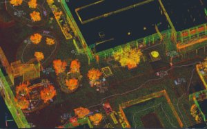
Traditional topography is exceptionally accurate, but it is a static file. With 360 Topography, project teams receive the conventional survey deliverables, along with immersive 360 imagery and survey-grade point clouds that let you view the site from nearly any angle at any time.

“It indiscriminately captures everything in context at once. At the beginning of the project, you can extract just what you need. But then as the project changes, you can go extract more without going back to the field.” —Brian Laird, Associate Principal
RICK developed the term “360° Topography” to describe a topographic survey that brings together conventional survey deliverables with immersive 360 imagery and survey-grade point clouds into a single source of truth that project teams can continue using throughout the lifecycle of a project.
Hear from Associate Principal Brian Laird as he explains how 360° Topography gives project teams access to a complete digital record of the site, reducing return trips to the field while making survey data more accessible throughout the lifecycle of a project.
Campo Road
Campo Road was one project in which the team saw the value of 360° Topography. It was a County of San Diego project involving the redesign of an existing roadway and sidewalks.
Typically, when you survey something like a fire hydrant or traffic signal box, the standard of care is to survey the center of it and represent it with a symbol. You know it’s there, but what you don’t know is how big it is.
On Campo Road, the project team needed the physical size of the water meters, traffic signal meters, and boxes in the sidewalk.
“Instead of going back into the field, we were able to acquire the information from the computer directly. We didn’t have to revisit the field, we didn’t have to coordinate with the County, and there didn’t have to be any additional traffic control. With the air conditioning on, the team was able to extract those points in the office and add it to the composite file.” —Brian Laird
 Associate Engineering Designer Carly Starkey remarked that laser scanning has become a tool she uses almost every day. On the Campo Road project, it gave the team access to information they wouldn’t have known to request during the initial survey.
“360° Topography allowed us to measure and see the most recent pictures from the site without having to rely on Google Maps or online imagery that was years out of date. We were able to access information in the laser scan that, when requesting survey, we would not have even known we needed, but since it was scanned, we had it.” —Carly Starkey, Associate Engineering Designer
 Assistant Project Manager Amin Bandegi, who also worked on the Campo Road project, says the ability to work directly with the data changes how the design team approaches a project.
“It truly feels like you are on-site taking physical measurements of an existing object. It increases the level of accuracy on your proposed items and reduces the number of site visits. This is a highly effective way to highlight location-based issues that require further client and team review.” —Amin Bandegi, Assistant Project Manager
Expanding Access
RICK has been using this technology for more than 15 years. One of the firm’s first major laser scanning projects was completed on Santa Monica Boulevard in Beverly Hills in the early 2010s, using point clouds and survey data to create a detailed digital representation of the corridor.
Back then, the technology came at a very different price.
“Fifteen years ago, the technology and tools priced us out of doing this, except for the most complex of projects or when the client specifically asked for it. Now, the price point is much closer to a conventional survey, which allows us to offer it as part of our value as an engineering firm. It differentiates RICK from conventional services because we can provide the traditional deliverable along with a much more complete record of the site.” —Brian Laird
As the technology has become more affordable, it has also become more widely adopted across the civil industry.
“Historically, we’ve worked with Reality Capture inside buildings. Now, the civil world is starting to request it more and more.” —Brian Laird
Traditional topography will always be the foundation of site design, and 360° Topography is changing what project teams can expect from a survey. As the technology becomes more accessible, more projects can benefit from a complete digital record of existing conditions that continues to provide value long after the survey is delivered. As projects evolve, 360° Topography evolves with them, giving project teams a resource they can continue using from design through construction.